![]()
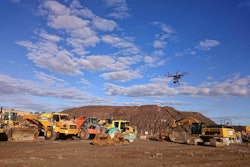
On most trips to John Deere’s Coal Valley, Illinois, demonstration site, Equipment World editors are focused on the ground, specifically the yellow machines moving the ground around.
But on my most recent trip to Coal Valley, I spent some of my time looking up instead, as Deere representatives demonstrated the company’s latest product category: drones.
In the run up to ConExpo earlier this year, Deere announced that it had struck an exclusive distribution deal with Kespry, a San Francisco-based startup building drones that not only fly themselves but upload the aerial data they capture to the cloud where it is transformed into 3D, survey-grade models. The drones are leased to companies on a yearly basis. Pricing is between $30,000 and $40,000 per year.
At Coal Valley, Deere WorkSight instructor B.J. Bauman took us through each step of a Kespry drone flight. Impressively, within 10 minutes, Bauman had programmed the drone and launched it. In as little as 30 minutes after the aircraft lands, the system is capable displaying the resulting survey map. You can see the process of launching the drone in our video of from the demonstration right here:
The demonstration started with Bauman opening up the Kespry app on an iPad. With your lease of a Kespry drone, you are provided with the drone itself, 5 gigabytes per month of wireless data connectivity and an iPad. Bauman says the iPad is included because Kespry has registered your drone to that iPad specifically for data security purposes. (The Kespry app installed on any other iPad than the one included with your drone, Bauman says, will not be able to communicate with the drone.)