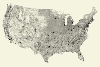
 A U.S. map with everything except roads stripped away. | Photo: Fathom
Check out the picture above: that’s what a U.S. map looks like once everything except roads is stripped off.
Boston-based design firm Fathom took away mountains, rivers, and place names to demonstrate how America is defined by its transportation infrastructure.
The project started several years ago when Fathom principal Ben Fry decided to create a map of the roads in Pennsylvania.
“During Ben Fry’s time teaching at Carnegie Mellon School of Design he created the map of PA as an example for one of use students. He says “…it’s one of those cases where even in a (relatively) raw format, the data itself is quite striking,” Terrance Fradet, a designer at Fathom, told Better Roads.
The Midwest maps show neatly organized grids of roads radiating from town to town because there were no mountains to get in the way. In New York, however, the Adirondacks and Catskills show up as blank spaces, while New York City is nearly black.
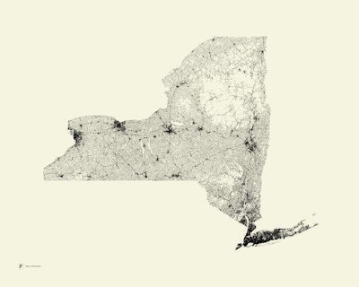 A map of New York with everything except roads stripped away. | Photo: Fathom
According to Fradet, once Fathom generated the code for mapping Pennsylvania, the rest of the states were fairly easy to create maps of. Alaska, however, was a different story.
“The code we wrote generates each state, so at first it is mostly automated. However more time was spent adjusting the placement of each state in two standard poster sizes, and making tweaks to stroke weights based on each state’s size,” he told us. “Alaska surprised us because of how few roads there were, it’s the only state that’s not recognizable.”
Fathom has received so many requests for print versions of these maps that the company is now working on road maps of several countries around the world. In fact, maps of nine countries have already been published and several more are in the works.
Related Read:
Roads could be used as solar generators to power the world
“We received many requests for a print version of the All Streets contiguous U.S. map, so in 2011 we printed the first run of 500. We found it curious that while the TIGER/LINE data has been available for some time, it wasn’t yet accessible in a quality print,” Fradet says. “It’s been kind of a rabbit hole; since we made the U.S. map we’ve gotten requests for states, countries and even cities. A combination of public interest and donating all proceeds to charities we’ve selected, has pushed us to continue to develop it year after year.”
Road maps of every state are now available as a print on Fathom’s website. The company is currently working on maps of other countries.


